Thursday, June 23, 2011

The art of geographic data

Geographic data which we know are mostly rasters or vectors. Tables. Attributes. Numbers. All very analytic. For some people boring. But is there a beauty in it? Not a beauty for a scientist but in a general sense... Is there an art of geographic data? Aaron Koblin - artist specializing in data and digital technologies - proved that its true. In his project called 'Flight Patterns' Koblin visualized airplane traffic over North America over 24h. 


And the image of Atlanta International Airport:


We can see how the pattern is changing over time due to different time zones of east and west US.


Do you still have any doubts that geographic data can be an art?


source: Aaron Koblin

Wednesday, June 15, 2011

C3 Technologies - Google Earth killer?


C3 Technologies - company with its origin in the Swedish aerospace and defense company Saab AB, is now applying previously classified, military image processing technology to the development of 3D maps as a platform for new social and commercial applications. And the effect is astonishing especially knowing that according to the company its generated automatically. It is a very promising 3D data capturing and visualization solution for the navigation and geographic information systems industries.

How do they do that? 

C3 maps are assembled almost automatically using high resolution, spatial areal imaginary. So basically their planes are outfitted with photogrammetric cameras pointing every direction and capturing overlapping images. Knowing the GPS position, angles, rotation and distance between cameras their are able to almost automatically generate 3D, photo realistic, stereo-graphic view on a captured area.


Previously similar data could be captured by LiDAR - remote sensing technology that uses laser scanning to collect height or elevation data. LiDAR is however pretty expensive technology. We don't know the initial costs of the C3 technology but it seems very cost effective in use. Google Earth from the other side involves using Google SketchUp 3D modeling. That means that people are almost manually putting parts of maps together which is is very time ineffective. 

Nokia OVI Maps 3D 

C3 Technologies has partnered Nokia to deliver the first usable version of its mapping data with Ovi Maps 3D in the begging of 2011. Currently it features 20 cities with limited functionality: pan, zoom, changing view angle. Company claims however to have 100 city models already produced with 22 more scheduled for Spring 2011. With this functionality its just a gadget to play and to check the possibilities of C3 technology. But does it mean that Nokia will use this data in OVI Maps? I am looking forward to here something about it.  

Google Earth killer?

Definitely not yet. The potential of Google Maps and Google Earth is not rooted in 3D view but in data that they have collected and interoperability with open standards (like KML). Row 3D without data about roads, streets, POIs ect. is not very useful.

But let's concentrate on 3D view itself and compare two products: Google Earth and Nokia Ovi Maps 3D. I order to do that I decided to choose Sagrada Família, one of the most architecturally sophisticated church in the world, situated in Barcelona, Spain, designed by Catalan architect Antoni Gaudí in early XX century.


We can observe that C3 model is much more photo realistic. Shadows and amount of details is really impressive. We can see however that automatically generated 3D geometrical objects like towers or rooftops of building on the second plan are not perfectly represented and Google Earth has advantage in this field. There is as well difference is representation of trees and ground details between two models. In Google Earth they are flat and in C3 they are convex, however not really well represented. 

I'm looking forward to see some more commercial applications of C3 3D maps and how they will develop. Both Google Earth and C3 models have their pros and cons. Maybe in a future we  will witness fusion of both technologies.


source:  C3 Techologies, Nokia OVI Maps 3D

Garmin to acquire Navigon

On Tuesday 14th of June, 2011 Garmin - one of the most popular sellers of navigation and smartphone GPS software - announced that Navigon’s shareholders have signed an agreement for a Garmin subsidiary to purchase Germany-based Navigon. “This acquisition is a great complement to Garmin’s existing automotive and mobile business. Navigon has invested significantly in the European automotive OEM business, and we feel that we can rapidly expand our automotive OEM footprint and capabilities through this transaction,” said Cliff Pemble, Garmin’s president and COO. “With Navigon, we are also acquiring one of the top-selling navigation applications for the iPhone and Android platforms – something that we expect will help drive revenue for the combined company going forward. Combining Navigon’s and Garmin’s strength also improves our competitiveness and standing particularly in Europe.” Garmin said that Navigon will continue to operate as a subsidiary of Garmin and that the deal is still subject to regulatory approvals. 
A Garmin spokeswoman at the company’s Olathe headquarters declined to reveal what the company paid for Navigon, which is 90 percent owned by General Atlantic Partners, a private U.S. equity firm. Financial Times Deutschland reported this month that Garmin was considering paying more than $70 million.
Some analysts saw Navigon as a struggling company with just 5 percent to 7 percent of the European market. (It holds about 20 percent of the market in Germany.) By purchasing the company, Garmin perhaps saves Navigon and adds incrementally to its own sales in Europe. Garmin also was enticed by Navigon’s popular applications for iPhone and Android smartphones.
Garmin, Navigon and Dutch manufacturer TomTom, the European leader, have all seen their prospects hurt by the smartphone. Many consumers are forgoing purchases of handheld GPS devices and relying on applications in their phones instead. That has meant a shrinking market for GPS device makers, which have begun to battle for contracts to provide the devices built into the dashboards of cars and trucks. Garmin also has found rich markets in devices made for boaters, bicyclists and people looking to incorporate navigation into their athletic training regimens.
Navigon was founded in 1991, two years after Garmin. The German company’s first signature software product debuted in 1996 as Autopilot, later named AutoPilot 2000. The company continued as chiefly a maker of software until 2008, when it began to sell its own navigation devices. But the timing proved poor with the spread of navigation-enabled smartphones, and Navigon quickly pulled its devices from the U.S. market. Worldwide, Navigon has more than 400 employees. Garmin has about 7,000 workers and more than half the American GPS market. TomTom, its chief competitor, has just less than half the European market and a fourth of U.S. sales.
source: Engadet, The Kansas City Star

Wednesday, June 01, 2011

GeoCommons 2.0 - Web based mapping platform

Web based mapping platform GeoCommons launched it’s 2.0 version yesterday. GeoCommons is the internet service where users can share, transform, visualize and mash-up geograohical information. The new version of the platform includes HTML5 display, a visualization engine GeoCommons says is capable of displaying hundreds of thousands of data points, web based editing, time-release views of mapped data and many other changes.

Why to use?

GeoCommons is a online free application that allows to use some of functionality of traditional GIS desktop software. It allows to:

  • design, make and visualize multi-layer maps
  • perform temporal visualization
  • share over popular platforms like Facebook, Twitter ect.
  • embed maps on a blog or website
  • geo-coding (by uploading CSV speadsheet)
  • convert data (e.g. Shapefile to KML !!! )
  • filter geographical data
  • open access to geographical data
  • access open API for developers
And what's best about it. You can do it in 10 minutes!!!

Drawbacks?

One need to stated as well disadvantages of the project. Fist of all the unknown accuracy of the data uploaded by users and other sources such as government agencies or non-governmental organizations. The only way to estimate accuracy of the data is to rate it, which for many purposes is basically insufficient. Secondly the data uploaded by users are open to others, so performing some business analysis is impossible.

Although there are pros and cons the tool is definitely worth exploring.   

Quick example: Map of Royal Wedding Tweets in 2011:


Learn more about GeoCommons:

source: GeoCommons

Saturday, May 28, 2011

Nuclear power mapped by BBC

"Twenty-five years on, the disaster at Chernobyl casts a long shadow over the nuclear industry, which has been compounded by recent events at Fukushima in Japan. Nuclear power had a rapid rise in the decades after World War II, but the growth in reactor numbers has levelled off. Use the map and audio commentary below to see how civil nuclear power has spread across the globe, and hear about the challenges it faces."
(http://www.bbc.co.uk/news/world-13159407, 2011)

BBC presents very simple but interesting flash based map on their website.


source: BBC

AIDA 2.0 – 3D, Interactive Dashboard Car Navigation

AIDA 1.0
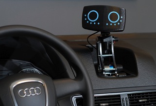
In 2009, MIT and Audi researchers created AIDA, which stands for Affective Intelligent Driving Agent. The first generation of the project produced a somewhat creepy and 'very friendly'  in-car robot. AIDA 2.0 - the second generation of the project looks however  more like the product of a science fiction movie. It uses 3D graphics projectors to display interactive map on a dashboard of a car! 

AIDA 2.0 identifies goals of the driver? 

AIDA 2.0 is meant to be a highly intuitive navigation technology that using the current location-destination-waypoint model and analyzing drivers behavior will identify goals the driver would like to achieve. That means it tries to help you locate food you like when you're hungry, movies you might like to see, or places you might like to shop. It will be as well connected will social networks so that the driver will be informened not only about places nearby that may be of particular interest but as well about people, friends and family.

AIDA 2.0

AIDA 2.0 learns your habits? 

AIDA 2.0 allows for a gesture controlled display that also handles the stereo and climate controls. It’s designed to learn your driving habits, preferred destinations, and typical routes. It offers you advice for your trip by determining your objectives and goals. It learns things like your favorite restaurants and activities and will make suggestions to you based upon your favorites. The more you use the system, the better it becomes. It “learns” more about what you want to do, see, and where you want to go. The display on the dashboard is optimized to help you achieve those driving goals. It takes into account real time weather and road conditions, including traffic delays. Using 3D graphics and a detailed map of the surrounding business, residential, and shopping districts, AIDA 2.0's truly stellar feature is the virtual display: it uses the whole of the car's dashboard and side mirrors to display and relay information.

Things that we used to watch in the sci-fi movies are now existing technologies. AIDA 2.0 is aiming to redefine the way we look at navigation systems.  We will see if the concept succeed.


source: moto.pl, motorauthority.com,

Sunday, May 22, 2011

Sudan's referendum 2011 - Analyzing Social Media

Bronwyn Agrios, Esri technical marketing, discusses the use of crowdsourced information and how to analyze its value in space and time. It's an interesting example of using Tweets to analyze global information flow.


source: Esri

Saturday, May 21, 2011

Loopt - showing location-based Groupon deals

Loopt is a checkin app founded in 2005.  The company produces mobile Location-based services that allows you to discover new places, download coupons, and share your location with selected friends. Not a bad idea but on the saturated market of location based social networks and some functional issues (spamming text messages) the Loopt was not a big success

Location-Based Services with Groupon?

Loopt seems to be trying everything in order to survive in a saturated space. It is now partnered up with Groupon Now! in Chicago in order to provide Loopt users with locationally relevant realtime deals around them. Notifications of users will work even when app is not open, and the time sensitive Groupon deals will also appear on place pages within Loopt, so users can see and share with friends their favorite relevant deals. Currently the specific Loopt service is only available in Chicago but the company is planning to spread it nationwide. 

Loopt has basically beat Groupon to bringing this Location-Based Service to its own app, while with Groupon users still have to type their zip code to get more locationally relevant deal notifications. But Groupon recently acquired Pelago, the company that have created Whrrl so their are probably working on a similar functionality right now. 

According to Groupon 14% of subscribers interact with daily deal push notifications. So strategic partnership between Groupon and Loost seems to be mutually beneficial. But one can't help but wonder when Groupon will apply this same technology to its own mobile app, what exactly that will mean for Loopt long term?

source: TechCrunch, Loopt

Wednesday, May 18, 2011

Zaarly - realtime, local marketplace

Zaarly is a web and mobile service that connects buyers and sellers in a localized market place. In other words it links people who want to buy something with those who want to provide it. Zaarly was officially lunched to the public today. 

Start-up

Zarly is a story of an incredible start-up. The company’s founding team built the prototype for Zaarly in February 2011 at Startup Weekend Los Angeles. The company won this competition, raised 1 mln dollars funding from business angels and investors,  including Ashton Kutcher, Felicis Ventures, Paul Buchheit, Bill Lee, Naval Ravikant and Lightbank and then debuted a test run at SXSW in March, where Zaarly processed over $10,000 in transactions in less than 48 hours.

How does it works?

Basically you post what you’re looking for using mobile application, how much you’re willing to pay for it and how soon you need it (for example "Tickets for a concert in 90 minutes for 100$". Zaarly will then share your request in the local community through the platform, as well as Twitter and Facebook. People or businesses nearby can access and see your request and then anonymously message each other to complete the transaction of delivering the cupcakes you want. Sellers bid for the tasks, and the buyer chooses the best one, with Zaarly connecting the two via an anonymous Twilio-powered phone number. You can use cash or Zaarly’s integrated credit card payment system to pay for the transaction.

What's innovative about it?

It is actually the first time when buyers are in charge of what they want to buy, how much do they want to pay for it and how soon do they want it. So basically it is the first service based on buyer driven model instead of seller driver model. It's an innovating way of approaching the market. It creates new way of looking at a time value of money: How much are you willing to pay for something to be delivered in 5 min versus if' need to wait for it for 3 couple of hours.Time will show if consumers will go for it...

Learn more how Zaarly works:


Presentation of Zaarly on LA Startup Weekend:


source: Techcruch, Zaarly

Sunday, May 15, 2011

The Last Episode of Geospatial Revolution

There is the new Geospatial Revolution episode available online. The episode title is Mapping Power to the People and it presents use cases of GIS to help people all around the world. Unfortunately it the last episode of the series. We are waiting for similar projects!!!


source: http://geospatialrevolution.psu.edu